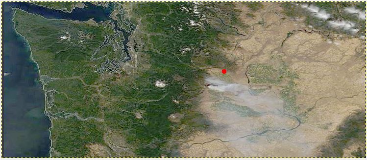
 We are the red dot north of the smoke. A map for Tuesday, below, is a zoomed image.
Mt. Rainier is the white place to the left.
Monday, Aug 31
At 2:30 p.m. today, a fire arsonist is suspected to have set a fire about 25 miles SW of us in the dry grass and trees near Wenas Lake north of Naches, WA. Official name is the Evans Canyon Fire. Many images are now on the web.
I spent a bunch of time talking with friend and former student, Kathryn Buckholz south of the fire on the other side of Cleman Mountain. She is currently in an area with an evacuation notice #2 (get ready to leave home). Spellings in the area are confusing. The fire came up Umtanum Ridge [The Road is spelled with a ‘p’, Umptanum; while most spelling of “tanum” are “taneum”], The first ridge south of EBRB is called Manastash Ridge, then Umtanum, then Cleman.
Kathryn sent a couple of photos of the smoke from her backyard, and Wayne Erickson took one from the north side of the fire: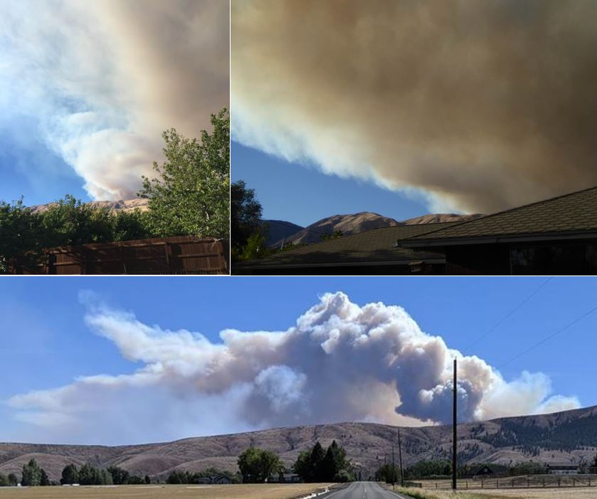 Top two photos from south with Umtanum Ridge in the background, left was 2.5 hrs prior to 2nd, by Kathryn Buckholz. Bottom taken from Cove Rd in the Kittitas Valley, the North view over Manastash Ridge, the next day, by Wayne Erickson. Story continues through the week.
A related new Nick YouTube video is scheduled at 6:00 p.m. tonight,
From WikiPedia: Manastash Ridge is a long anticline mountain ridge located in central Washington state in the United States. Manastash Ridge runs mostly west-to-east in Kittitas and Yakima counties, for approximately 50 miles. The ridge is part of the Yakima Fold Belt of east-tending long ridges formed by the folding of Miocene Columbia River basalt flows.
‘Nick on the Fly’ #20 – Manastash Ridge Field Trip, 8-31-20 (42 mins)
Supper: Pan fried chicken breast pieces with onions and lots of red grapes, strawberry ice cream for dessert.
Tuesday, Sept 1 – – Nancy’s Birthday! – –
A beautiful valley sunrise starts my special day: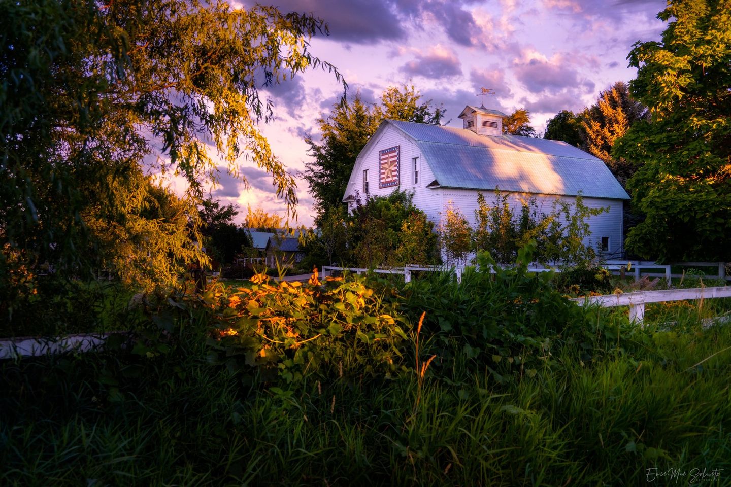 Sunrise over lovely “quilt-barn”, photo by EvieMae Schuetz
Today was our day to go to Ellensburg for the 10% off Senior Discount the first Tuesday of each month, to check our Bi-Mart numbers, plus pick up a bag for a Game Day this week at the Senior Center. While on the drive in, we saw significant smoke coming from the Evans Canyon Fire. Once home, we immediately added the Modis Satellite Imagery (Active Fire Mapping) to our Google Earth Pro to check out the fire’s hot spot history. An early image is below and the spots are all are bright red, meaning they started within the previous 6 hours.
Also, the fire is still not under control, and people have been evacuated. More than 100 dwellings threatened & high winds continue and fire acreage more than doubled. It has made it to MODIS satellite view. John just snipped this image for me to share, with the study group I was going to be sending a reminder for the video to be presented Wednesday night.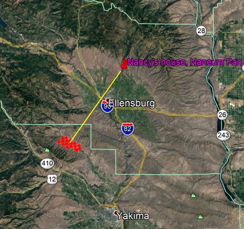 I’m showing this here for you to compare in 4 days with what I will post below on 9/4 of the entire footprint of the fire, which has all the values (in the map legend) of the boxes and the colors and the spot in the center of the square, indicating the initial posting of a fire at that location. The dark red is 0-6 hrs since starting.
Supper: For dinner: spaghetti with meat sauce (93% fat free ground beef) we got on sale today, pears, and Rose’ wine. Rather than “birthday” cake, we are having peach pie and ice cream for dessert.
Wednesday, Sept 2
I haven’t figured the best way to thank everyone on so many platforms (Facebook, Email, Postal mail, phone calls) for all the birthday greetings I received. Do not have time to thank individually, with all this fire problem up to 13,000 acres now, major evacuations, extra firefighting crews called in, and high winds continuing. I’m sure this bunch is exhausted from fighting overnight. Not nice.
The Fire continues out of control to 15,000 acres, 0% contained, topped the ridge and now will be advancing down into the Umtanum Canyon which slopes eventually to the Yakima Canyon river road. Also, some rural areas nearby adjacent cities (Naches, Selah) are on immediate evacuation notice.
Right now our valley is not threatened, but the footprint is spreading rapidly. During the day they have airplane assistance and bombers with pink retardant spray. The jet resupplies at Moses Lake as it did when if flew over our house for the Snag Canyon Fire, 2014. Other planes and helicopters are involved.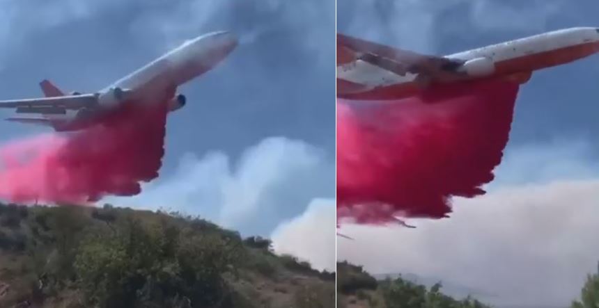 These I snipped from a video taken by a firefighter on the ground.
Unrelated: Not good 18 min waiting to renew our blog’s domain name, and never got my call back. I deleted the charge box and closed it. Will wait for Oct 2 automatic renewal and hope my change in credit card number worked and they renew for $16.99 for 2 years. That up significantly from the charge for two years in 2018, last time we renewed. Jason was supposed to return my call, but he did not.
For Nick fans, a short introduction to a new series started in a week on Sept 9th.
I know you have already been warned about this tonight, but want to add to the story, as you get on to watch:
‘Nick on the Fly’ #21 – Thorp Cliffs Field Trip
CWU’s Nick Zentner leads a virtual GEOL 101 LAB field trip from the Thorp Cliffs in central Washington. 30 minutes.
While you are waiting, watch the 2-min video below at the start, announcing a new series starting in a week on Sept 9th evening.
‘Nick from Home’ Livestreams return Wed, Sept 9th!
CWU’s Nick Zentner launches a new set of livestreams…this time with a theme. ‘Exotic Terranes from A to Z’ begins on September 9 and runs through early December of 2020. Wednesdays at 6:00 pm Pacific and Sundays at 9:00 am Pacific. Join us!
Thursday, Sept 3
Starting with a cute picture of a 16-year old girl in Idaho with her new puppy, a French Brittany. Back in the late 1990s we sold an orange and white Brittany to the family, we’d had for 3 months, and had named Brick. They actually picked him up from us in Ellensburg, but then they moved from WA to the Midwest (Iowa), and we lost track. They were moving back to Idaho, and decided to search for us. Found us still here. When I explained we were no longer breeders, they searched and found this puppy. He and she are so cute. 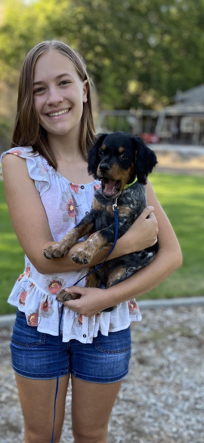 Rebecca with her puppy Brooks, a French Brittany.
This is a video Nick put on for anyone to watch at any time. It was not published as a Premiere version with a livestream chat. He’s checking options to prevent buffering on his Premieres that have been happening.
This is well worth the watch for the two field trip stops 1 and 2, especially now that this lab will be viewed by the first meeting of his Geology 101 freshman class, next Wednesday, the first day of classes this fall quarter as a virtual field trip. Currently, it’s good he was practicing with us and filmed it in advance because now that road is closed and he could not even get there because of the current wildfire. Next is the field trip he was filming for them to take for their first Virtual Field trip of the quarter.
‘Nick on the Fly’ #22 Yakima River Field Trip (32 mins)
CWU’s Nick Zentner leads a virtual Geol 101 LAB field trip from the Yakima River in central Washington.
The Evans Canyon Fire increased to 52,000 acres and evacuation 3 notices (GET OUT NOW) posted to the Yakima Canyon Road. The road is closed at Thrall Rd (entrance to the canyon just south of EBRG), all the way to Selah. So any locals who planned to go to the two Field Trip stops Nick showed us last night, will have access only to the Ringer Loop Stop 1, and NOT to Stop 2, at the debris flows. (as of tomorrow, the fire jumped to Ringer Loop Rd, so Stop 1 is unavailable too).
Be sure to note to have read the Martin K. Kaatz publication before viewing yesterday’s Yakima River field trip. (Thanks again to Jessie Bunker-Maxwell for researching this for the study group).
July 3, 1998 Yakima River Debris Flows – Martin R. Kaatz
Marty was a CWU geographer, and hiking friend of John.
This was presented as a premier, and at a time when all could view it. (6:00 p.m.)
‘Nick on the Fly’ #23 – Snoqualmie Pass (26 mins)
CWU’s Nick Zentner improvises at Snoqualmie Pass in central Washington. The Yakima Valley Glacier and Guye Peak sandstone are discussed. Recorded on August 22, 2020
Friday, Sep 4
John and I had setup our Google Earth Pro with Active Fire Mapping Software to capture MODIS Satellite imagery of the hot spots of the fire, so we could be following its path. This is from 9-4-20 just to show the location of the fire jumping down near the entrance/exit we usually take at Thrall Rd, when returning north on I-82 {aka WA 97}.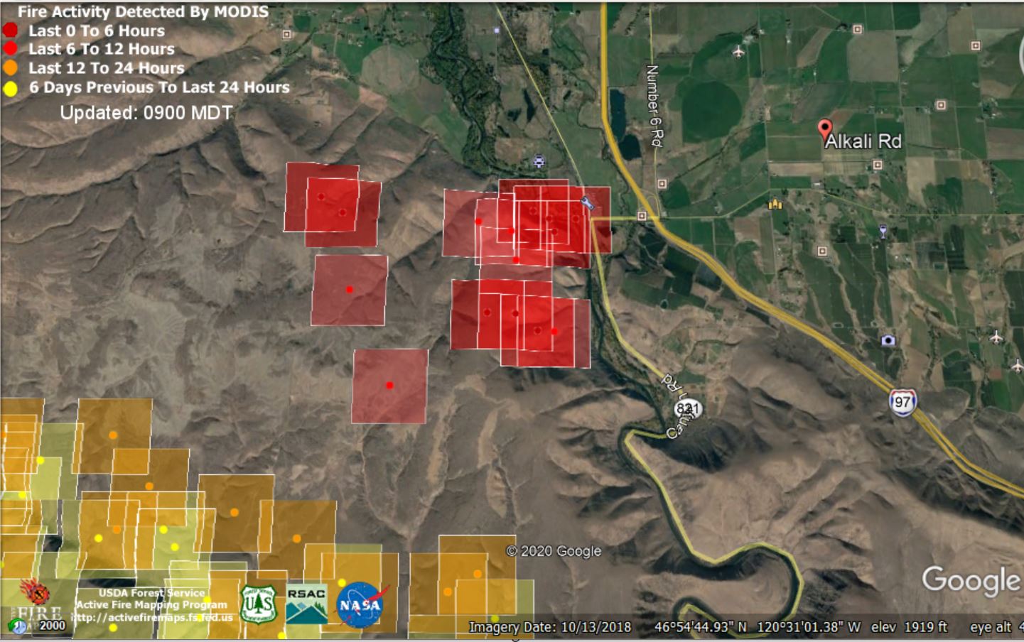 The fire has crossed the ridges and has come into our valley, and is at Ringer Road.
High winds overnight advanced the footprint of the fire from 2,500 acres to 52,000 acres; eventually growing to 64,000 acres. And changed evacuation orders at 9:00 p.m. last night to #3 (get out immediately), in several areas.
This is 3 miles from the south edge of Ellensburg. Not likely a threat to town because of being surrounded by irrigated agricultural farmland and roads. Everything north of there is on irrigated farmland, and will not be sagebrush and burnable cover (cheat grass) for many miles. Except our property is north of the highest canal, so we are in the semi-desert shrub-steppe.
However, I’ll add some fire photos made today to show the view during the late afternoon today, by EvieMae Schuetz.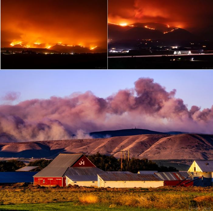 The hills are a’fire; taken from Alkali Rd (marker in prior map) by EvieMae Shuetz; The smoke picture she took from Clerf Rd east of Kittitas, WA.
This morning at 10:30 a.m. I joined a Zoom session at the Senior Center with 3 others for Game Day this week. I was playing a card game with two decks of special game cards, one Red and one Green. Neither of the players had ever played the game before. It is called Apples to Apples. A staff member was the leader and the judge, keeping the scores and explaining the game. The youngest gal there, was the winner with 16 pts. I had 9 pts. It lasted the full hour plus a few minutes. Next week the same folks will continue a game we played last week, Yahtzee. We all like that game and are happy to repeat it. It’s a short week because they have a Holiday on Labor Day. Our leader will actually be on vacation at the beach all week so the director will likely be our game leader. It will be at an earlier time on Thursday, next week.
Afterwards, we were scheduled to go to town for Flu shots with our pharmacist, but with the severe smoke in the atmosphere, I decided to stay home and inside with the a/c in our house to filter the smoke particulates. We rescheduled for a later date in Sept.
Today, we got 4 scammer calls, with two each coming from the same number, one from Missouri and the other from Issaquah, WA. I blocked them both for the future.
I’m not sure all of the outside chores John accomplished today, and I was worried for his being out in the smoky air. He says it was “not too bad.” We had worse smoke in our valley today than in recent days, because of the wind direction. The Evans Canyon Fire is still raging. The Yakima Canyon Road at Thrall Rd is now closed to any traffic (except evacuees and firefighters, until Tuesday, 9-8.) Firefighters are poised to prevent its crossing the Yakima River and burning upslope to reach Interstate 82.
Tonight at 5:00 I went on line on Facebook: to this site, the inciweb.nwcgov/incident/7132/ link to get the Facebook link to a meeting with the community about the Evans Canyon Fire. It was a bit disappointing and did not provide much information I didn’t already know from local social media. The only new information received was depressing, and that was that 6 structures (homes?) were totally lost in the fire along with several outbuildings. We have yet to hear if any of our friends who were evacuated lost anything.
Clarinet music from Kathy Williams-DeVries in Brisbane, Australia.
Kathy Plays Reger 9-4-20 (80 mins)
Supper: tonight we ate late, but had meatloaf & potatoes, and a piece of Key Lime pie for dessert.
Saturday, Sept 5
This morning at 9:00 a.m. is a premiere YouTube showing.
‘Nick on the Fly’ #24 Seattle Glacial Till, 9-5-20 (37 mins)
CWU’s Nick Zentner visits glacial deposits in Seattle, Washington. Recorded on September 1, 2020.
I was tired from a restless night, so decided to take an afternoon nap. Guess I needed it, as I slept for an hour. Might not have awakened if John hadn’t come in the front door.
Worked on the geology study group necessities planning for the future (the first, tomorrow a.m. at 9:00 a.m) and then adding a new member to the study group. Also, had to load the dishwasher.
Supper: Meatloaf, potatoes, and fried cauliflower; butter pecan crunch ice cream for dessert.
Sunday, Sept 6
‘Nick on the Fly’ #25 – Icicle Creek Exotic Bedrock 9-6-20 (49 mins)
Nick’s explanation of this video when introducing it:
“We started up canyon at the Chiwaukum Schist and viewed that, (coming on down the canyon, we realized that the Mt Stuart Batholith is younger and intruded into the Chiwaukum Schist, and at the same time also intruded up into some of the Ingalls Terrane which was all that Ultramafic Mantle material. This area is a key portion for the Baha-BC discussion and unraveling the exotic terrane history in the northern Cascades.”
It’s our lead into a new Nick from Home livestreaming on Exotic Terranes in WA, accreted on from Mexico when Mt. Stuart was moved from Mexico to British Columbia, but because of offset eastward rotation, Mt. Stuart stayed in WA. Geological history of our region, this theory is now well-followed by the science community. Those lectures officially start this coming Wednesday evening at 6:00 p.m. and continue for 26 episodes two days/week until December. The 2nd day is Sunday morning, at 9:00 a.m. to pull in the European community.
Brunch today: cheese bratwurst and Protein shake.
At 12:40 we received a disturbing call that there was a fire a mile west of us headed east, so I have been logged onto the police scanner listening. Sandy Meier called to warn us the fire was in our vicinity and 6 fire trucks had gone up Wilson Creek Rd by their house. John got in the car and found a deputy sheriff at the Corner of Naneum and Thomas Roads, who told him the firefighting crews knocked it down, and there was no longer any danger or need to evacuate. The cause was a backhoe hitting an electric utility pole on Frontier Rd, which fell, starting the fire within the Rustic Acres subdivision, in the “rural area” north of Ellensburg, with Wilson Creek Rd on the west, and an east-west road along the south side, Thomas Rd. This development is accessible about a mile west of our home. At the time, of the fire report, the winds were blowing from the west, at 21 mph across dry shrub-steppe vegetation and much cheat grass toward a forest of trees along a creek.
Another warning we had was from our neighbor a mile north on Naneum, who saw the smoke (we had not seen, and can’t because of the trees to the west). Allen and his son drove down to check it out and talked to a sheriff’s deputy at the closed road on the north side to get to Wilson Creek, Rd, closest to the start of the fire on the west side of Thomas Rd. So he had heard the same story as John did on the East side of Thomas.
As they drove up, I received a return call from a friend on Thomas Rd east of the start of the fire. They were receiving a lot of smoke in their location and realized how they might be evacuated, when hearing the fire engines arrive. They were packing their motor-home with all their important papers, to be ready to leave. They were notified by a deputy sheriff very quickly when the fire was contained. The Public Utility District crews are now replacing poles and wires.
At 3:00 p.m. today, temp at airport is 94°; temp on our front porch in the shade is down from 94° earlier to 90.5°.
John is preparing a major chore today for a Monday happening. We will be draining and flushing our water heater to get out the crud in the tank, and the hose has to come out of the back patio door, which is the west side of the house and our hottest outside part of the house. Power to the tank has been shut off and we have continued use of that water. Thus, it is now cooled. Those in the know suggest this flushing be done once a year. Don’t ask. Okay. Never. New tank 15 years ago.
John started his nap at 3:25 waiting for the temp to decrease before going outside, and slept for over an hour.
I need a nap too, but I need to finish this blog as well so we can go to bed earlier tonight. I’m enjoying a cool PoweradeZero drink of Strawberry/Lemonade while working on photo insert creations for the blog.
Today’s activities now include finishing the blog, unloading dishwasher, putting medicines in for the week. Enjoying Labor Day holiday. Ha! Retired. Every day is a holiday.
Supper: Cheezy biscuits and Beef Stew.
Wind is still blowing but John just opened the windows in the house and the temp is down to 79°.
Here’s one last view of the fire extent ending this morning and still okay. The fire is contained with a “footprint” of 75,800 acres. Not everything therein burned. Report by authorities will follow.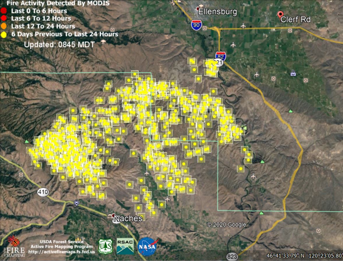 Hope your week was fine.
Nancy and John
Still on the Naneum Fan