Here is a satellite view of central Washington State. My places is the red star. Moses Lake is 55 miles east. The orange Q is Quincy. The green lines are 120°W Longitude and 47°N Latitude. That thinner green line passes almost over the Ellensburg Street along which Central Washington University’s first buildings were constructed.
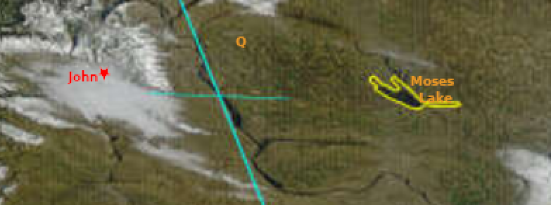
The Kittitas Valley is filled with fog. That’s the gray stuff. The brighter white is snow.
Thanksgiving Day – bright and sunny – I went 8 miles SE for the afternoon. Lots of people, lots of food. While still light, but with dusk approaching, we could see fog creeping down the hills to our northwest. I encountered fog just a mile south of home. It has been here ever since. I had a few sunny minutes on Saturday.
Often, there will be clear sky here with fog starting about 4 miles south. Today I have fog near the ground and can see only about 100 yards. On I-90 near EBRG, the fog is not on the ground. Traffic cameras show clear driving with fog about 700 feet up. The National Weather Service thinks I am “Mostly Sunny” with a temp of 37°. It is 27° here and no sun. I was hoping to do a few things outside today, but will pass except for carrying in some firewood and taking sunflower seeds to the little birds. Monday about 2:00pm there may be enough wind to clear the Valley of fog.
I don’t need to go anywhere until Friday, so no big deal
Happy December!
Keeping Track
on the Naneum Fan
John